
About fifty historical maps that relate to Clay County are available online. Thanks to David Rumsey, Florida State University, and the Library of Congress. Follow the links at your own risk.
A gazetteer of place names may come in handy as you find places you are unfamiliar with or want to know spelling variations to search.
Before the Civil War
1733 Popple
Map of the British Empire in the Americas. An Indian village called Ivantanoa.
1736 Moll
Florida, called by ye French Louisiana & San Francisco [de Pupo], may be shown, but as seen from a 1776 map. San Francisco and [San Francisco de] Poppa are two distinct places.
1742 Covens et Mortier
Carte de la Louisiane et du Cours du Mississipi. Illatamaa (may be a corruption of Ivantanoa).
1769 Jeffrys
Map of East Florida. The map shows the [Apalachee] trail from St. Augustine westward to St. Mark / Apalache. Fort Poppa [Pupo] is shown on the trail.
1775 Jeffrys
The Peninsula and Gulf of Florida or Channel of Bahama. The Clay County area appears to be copied from the 1769 map since the places (Pupo) and features are identical.
1776 Sayer and Bennett
A General Map of the Southern British Colonies in America. The [Apalachee] trail from St. Augustine to St. Marks is shown. Poppa [Pupo] and Joltanoga are on the trail.
1794 Laurie and Whittle
A new and general map of the southern dominions. The Clay County area appears to have been copied from the 1776 Sayer and Bennett map since the places (Pupo and Joltanoga) and the features are identical.
1796 Carey
A Map of the United States: compiled chiefly from The State Maps. The Clay County area appears to have been copied from the 1776 Sayer and Bennett map since the places (Pupo and Joltanoga) and the features are identical. However, the St. Augustine to St. Mark [Apalachee] trail is no longer shown.
1806 Carey
A new map of part of the United States of North America. The Clay County area appears to have been copied from the 1776 Sayer and Bennett map since the places (Pupo and Joltanoga) and the features are identical.
1810 Arrowsmith
Composite of the West Indies. The St. Augustine to St. Marktrail is shown, but now only Poppa [Pupo] is shown.
1811 Carey
Map of the United States. The Clay County area appears to have been copied from the 1796 Carey map since the places (Pupo) and the features (no trail) are identical.
1815 Melish
Southern Section of the United States, including Florida. This map shows distances on the Apalachee trail. From Poppa to Jotanoja is 25 miles. This would put Jotanoja (Joltanoja) inside the boundary of Clay County, possibly at the forks of Black Creek or in the Keystone Heights area.
1822 Fielding
Florida. This map shows Ft. Poppa [Pupo] on the Apalachee trail but shows Jocanoja (Joltanoga) above it.
1823 Vignoles (engraved by Tanner)
Map of Florida. Black Creek and its prongs are fairly accurately shown for the first time. The Old Indian Boundary established by the British to keep the peace is shown. Also shown for the first time is “Doctors Creek & Lake” and “Flemings L[and]”
The Apalachee trail, Pupo, and Jurlanoga are no longer shown, but a trail from Jacksonville crossing Black Creek and going west is shown.
1825 Tanner
Map of Florida
The Clay County area appears to have been copied from the 1823 Vignoles map since the places (Doctors Lake and Fleming Land) and the features are identical.
However, in other areas, features are different. For example, Micanopy (Wanton) is now an important stop on the old Apalachee trail.
1826 Finley
Map of Florida
Very poorly drawn map of our area, not showing as much detail as the Vignoles map, and no place names in the Clay County area. However, it does show two trails that lead to Micanopy (Wanton). The Northern one is the old Apalachee trail. The southern one crosses St. Johns at Palatka via the “Alachua Ferry,” with terminuses at Micanopy and St. Augustine.
1829 Swift
1831 Finley
A poor map compared with Swift’s 1829 one. It shows few features in the Clay County area. It shows The old Apalachee trail in place, without Micanopy. Only Black Creek is named.
1832 Hinton
Map of the state of Florida
A poor map showing almost the Clay County area.
1834 Poussin
Carte generale des Etats-Unis d’Amerique
While showing a few features in the Clay County area, it shows the route of the proposed canal and Old Hut between the forks of Black Creek. This may be Jurlanoga.
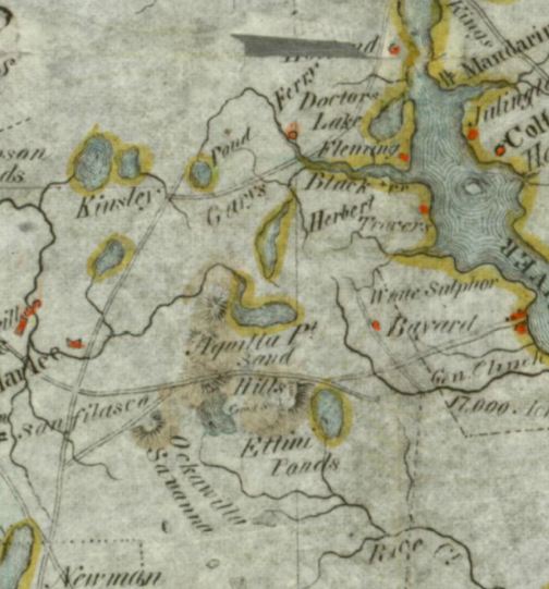
1837 Williams
A very important map, being the first to show Garey’s Ferry, the Travers grant, The General Clinch grant (Bayard), and White Sulphor (White Sulphur – Green Cove Springs). It also shows Doctors Lake, Black Creek, Kingsley Pond (Kingsley Lake).
It shows a road from Kingsley Lake through Garey’s Ferry and onto Jacksonville and a trail from Putnam north along the western Bayard border.
Lastly, it shows “Herbert,” just west of the Travers Grant. This is not referred to on other maps or found in other historical references.
1838 Bradford
Minimal detail and no roads. Only the Travers and Bayard grants are shown as dots.
1838 Hood
Shows Ft. Heileman at Garey’s Ferry, along the road from Ft. Harlee to Jacksonville.
1839 Burr
Map of Florida Exhibiting the Post Offices, Post Roads, Canals, Rail Roads
For the first time Whitesville is shown, but no other place names. A proposed canal is shown following the trail from Newnansville through Whitesville to north Jacksonville.
1845 Morse
Perhaps copied from the 1838 Hood map showing the same details: Ft. Heileman, Garey’s Ferry, and the road from Ft. Harlee to Jacksonville.
1846 Bruff
Shows the proposed railroad through Middleburg (never built). Place names are Whitesville, Ft. Heileman, Garey’s Ferry, and “Wee Iouka” (could be Wee Louka) — an area just west of the St. Johns, not referred to by any historical reference.
1850 Thomas, Copperthwaite & Co
Shows Garey’s Ferry, Whitesville, sitting on the road to Newnansville
1851 Philadelphia, Lippincott, Grambo & Co
Shows Whitesville on the road from Newnansville to Jacksonville
1859 Mitchell
Appears to be copied from 1850 Thomas since Garey’s Ferry and Whitesville sit identically on the road to Newnansville.
1860 Koerner
Sketch map of Northeast Florida showing the Florida Railroad
The creek system in Clay County is well charted. The only place name is Trail Ridge Station.
1861 P. S. Duval
Military Map of the United States
It shows only Ft. Heileman.
1864 Perrine
Perrine’s New Topographical Map of the Southern States
A beautiful, high-level map clearly showing the new Florida Railroad and the one-stop in Clay County: Trail Ridge Station.
1865 Julies Bien & Co
General Topographical Map Sheet XI [North Florida]
(Incorrectly shown as 1895 in the Rumsey Collection)
A very detailed map of the time showing
- McIntosh Steam Mill
- Sugar Works (Sugar Mill) on the north side of Doctors Lake
- Sugar Mill at Hibernia
- Steam Mill and Hotel at Magnolia
- Hibernia with houses
- Palan with houses
- Mrs. Monroes (which must have been rebuilt, or the map is incorrect
- Middleburg (no Ft. Heileman or Garey’s Ferry or Whitesville)
- The Florida Railroad with the Trail Ridge [station]
- The Federal Road (or Bellamy Road)
- A network of roads radiating from Middleburg
After the Civil War
1870 Drew
Drew’s New Map of the State of Florida
The first mention of Green Cove Springs on a map on the eve of its incorporation.
Middleburg, Hibernia, and Doctors Lake are also shown.
The outline of Laurel Grove is shown.
1874 Asher & Adams
This high-level map doesn’t show much detail, but it does show Laurel Grove, Hibernia, Green Cove Springs and Middleburg.
In addition, it shows a proposed canal from Webster to the Santaffe River, a little north of Waldo.
1881: Florida Dept. of Forestry
Long Leaf Pine and Clear Cutting
Shows that most of Clay County had been clear-cut. For an explanation, read about timber and sawmills.
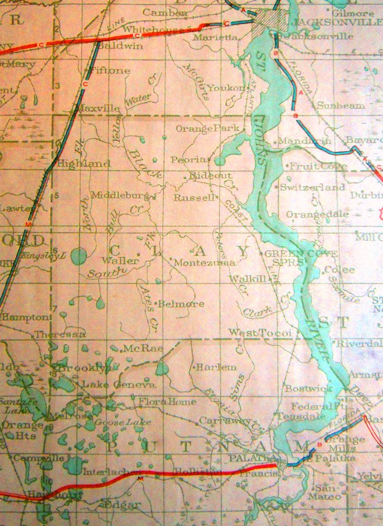
1877 U. S. Coast Survey
Progress Sketch Sec. VI, East Coast of Florida from Amelia Island to Halifax
One of a series of visual navigation aids on the west side of the St. John’s in Clay County, including Fire (at Duval County line), Doctor (Orange Park), Lake (where Doctors Lake bridge touches Fleming Island), Ragged (Raggedy Point), False, Middle, Hibernia, Wharf, White House, Fleming, Wilkies (just south of Black Creek), Magnolia (Point), (Magnolia) Hotel, David (Green Cove Springs), Clarendon (Hotel), White, Seppho, Draper, Red (Putnam County line) [from FL State Archives]

1882 Colt
Florida Transit and Peninsular Railroad and Its Connections
Shows Florida Railroad stops (Brainerd, Highlands), Laurel Grove, Orange Park, Doctors, Lake, Magnolia, Green Cove Springs, Bayard, Melrose, Wilderness, Kingsley, Brooklyn, Middleburg, and Gareys Ferry.
1883 Letts
Eastern United States No. 10
A rather poor map, still showing Whitesville and Garey’s Ferry. Only roads shown are the Newnansville to Jacksonville road, and Bellamy Road.
Hibernia and Green Cove Springs are also shown.
The Trail Ridge station is shown incorrectly outside the county.
1885 ACL
Map of the Atlantic Coast Line
A stylized map showing only railroad stations.
J, T&KWY: Hibernia, Magnolia, Green Cove Springs
Florida Transit & Peninsular (old Florida Railroad): Highland (and Maxville just outside the county line).
1886 Bushnell
New Map of Florida
The Florida Railroad is shown with the Highland stop, and Brainerd is not shown.
The J, T&KW stops are Orange Park, Fleming, Magnolia, Green Cove Springs, Clinch, and West Tocoi.
The Green Cove Springs & Melrose is depicted oddly and perhaps aspirationally. The line is dashed (perhaps “completed”) on the eastern segment and shows Sharon on the line and Novella and Belmore just off the line. It is solid to Melrose (perhaps “planned”) and shows a McRae stop (which, when completed, was off the line.
Several places are named off railroad lines, including Blue Pond, Sand Hill Lake, Crystal Lake, Kingsley Pond, Wilderness, Ionia, and Middleburgh.
1888 Florida Southern Railway
Lands for Sale in Florida
This map is similar to the 1888 Plant map, except land ownership is filled in.
It is unclear yet how the railroad received land grants in the interior of Clay County, far away from the lines. Perhaps the sections within six miles had already been purchased, and the grants were awarded farther away. In any case, there are dozens of sections owned by the railroad.
The Florida Railroad is shown with the Highland stop, but Brainerd is just off the line.
The J, T&KW stops are Orange Park, Peoria, Black Creek, Fleming, Magnolia, Green Cove Springs, Melrose Crossing, Walkill, and West Tocoi.
The Green Cove Springs & Melrose (on the map called the WN of Fla) is short, only running from Melrose Crossing (Clinch’s Bayard) to Florence Mills (shown with “Novella P.O.” under it) and ending at Sharon. Belmore is shown beyond the line.
Several places are named off railroad lines, including Blue Pond, Kingsley’s Pond, Sand Hill Lake, Middleburg, Webster, Ionia, McRae, Melrose, Wilderness, and Lake Geneva.
1888 Plant
The Florida Railroad is shown with the Highland stop, but Brainerd is just off the line.
The J,T&KW stops are Orange Park, Peoria, Black Creek, Fleming, Magnolia, Green Cove Springs, Melrose Crossing, Walkill, and West Tocoi.
The Green Cove Springs & Melrose (on the map called the WN of Fla) is short, only running from Melrose Crossing (Clinch’s Bayard) to Florence Mills (shown with “Novella P.O.” under it) and ending at Sharon. Belmore is shown beyond the line.
Several places are named off railroad lines, including Blue Pond, Kingsley’s Pond, Sand Hill Lake, Middleburg, Webster, Ionia, McRae, Melrose, Wilderness, and Lake Geneva.
1889c Cram
Railroads and Counties of Florida
The map is undated, and the Florida State Archives estimates 1887. However, based on the depicted extent of the Green Cove Springs & Melrose Railroad, the map is after 1888 and before 1891.
The Florida Railroad is shown with the Highland stop, but Brainerd is just off the line.
The J,T&KW stops are Orange Park, Ridgewood (the only reference known to this station name, where Peoria usually is), Black Creek, Fleming, Magnolia, Green Cove Springs, Melrose Crossing, Clinch’s, West Tocoi.
The Green Cove Springs & Melrose (shown but not labeled) is uncompleted, only having these stops: Melrose Crossing, Clinch (the only reference known to this station name), Peters Creek (the only reference known to this station name), Florence Mills, Sharon, Belmore and extending a bit beyond.
Several places are named off railroad lines, including Kingsley Lake, Sand Hill Lake, Middleburgh, Ionia, Kingsley, McRae, Brooklyn, Melrose, Wilderness, and Lake Geneva.
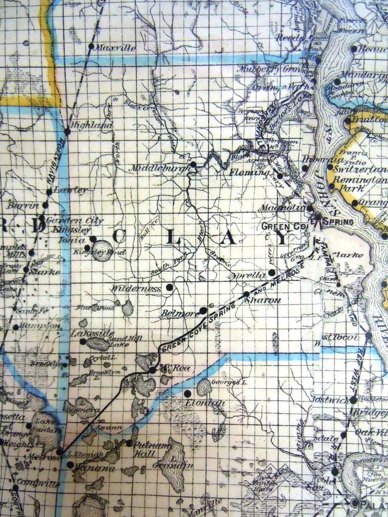
1891 Mathews-Northrup
The Florida Railroad is shown with the Highland stop, but Brainerd is just off the line.
The J, T&KW stops are Orange Park, Peoria, Black Creek, Fleming, Magnolia, Green Cove Springs, Melrose Crossing, Walkill, and West Tocoi.
The Green Cove Springs & Melrose (on the map called the Western Railway of Florida) stops are Wilkerson’s, Novella, Sharon, West Sharon, Belmore, Wilderness, Lake View, B & W Junction, Spring Lake, and Florence. Saranac, Melrose.
Perhaps B & W Junction implies a timber railroad crossing at that point.
Also shown are Middleburg, Webster, Kingsley, Ionia, and LakeView.
1893 Mathews-Northrup
The Florida Railroad is shown with the Highland stop, but Brainerd is just off the line.
The J, T&KW stops are Orange Park, Peoria, Willford (new), Black Creek, Fleming, Magnolia Springs, Green Cove Springs, Melrose Crossing, Walkill, and West Tocoi.
The Green Cove Springs & Melrose (on the map called the Western Railway of Florida) stops are Wilkinson’s, Novella, E. Sharon (was just Sharon earlier), Sharon (was West Sharon earlier), Belmore, Wilderness, Lake View, B &W Junction, Spring Lake, Florence, Athens (new), Kellums (new), Spring Lake (new), Newburg (new), Hunter’s Mill (new), Saranac, Melrose.
Also shown are Middleburg, Kingsley, Ionia, and LakeView. Federal Hill is new.
1893 Tucker
Phosphate Mines of Florida
Shows that the only phosphates in northeast Florida are along a long stretch of the South Prong of Black Creek and from the Fork downstream a few miles.
1894 Matthews-Nothrup
Very similar to the 1893 Mathews-Northrup map.
The Florida Railroad is shown with the Highland stop, but Brainerd is just off the line.
The J, T&KW stops are Orange Park, Peoria, Black Creek, Fleming, Magnolia, Green Cove Springs, Melrose Crossing, Wallkill, and West Tocoi.
The Green Cove Springs & Melrose (on the map called the South West Railway of Florida) stops are Wilkerson’s, Novella, Sharon, West Sharon, Belmore, Wilderness, Lake View, B & W Junction, Spring Lake, Florence, Saranac, Melrose.
Also shown are Middleburg, McRae, Kingsley, Ionia, and LakeView.
1897 Rand-McNally
The Florida Railroad is shown with the Highland stop, and Brainerd is no longer shown at all.
The J, T&KW stops are Orange Park, Peoria, Willford, Fleming, Magnolia Springs, Green Cove Springs, Wallkill, and West Tocoi.
The Green Cove Springs & Melrose (on the map called the South West Railway of Florida) stops are Wilkinson’s, Novella, East Sharon, Sharon, Belmore, Wilderness, Kellums, Spring Lake, Newburg, Smaile’s Switch, Saranac, Melrose.
Also shown are Middleburg, McRae, Kingsley, Ionia, and LakeView.
Waller (or Walter) is shown on the South Fork of Black Creek.
An intriguing “Middleburg, Highland and Lake Butler.” connects Middleburg, Highland, and “Log Wharfs.” This railroad is otherwise unknown, perhaps being a temporary timberline.
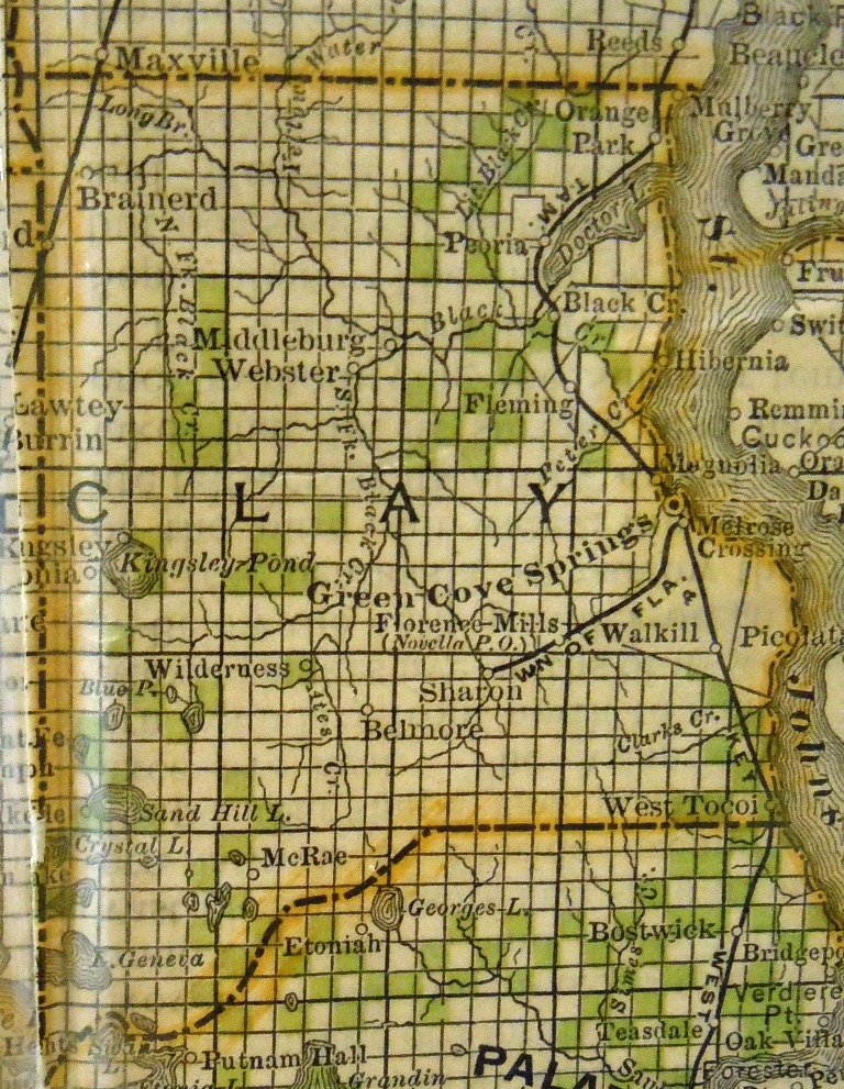
1900 Rand-McNally
<a href=”http://memory.loc.gov/cgi-bin/query/h?ammem/gmd:@field(NUMBER+@band(g3931p+rr001970))” target=”_blank” rel=”noopener”>Shippers Guide</a>
Appears to be a copy of their 1897 map with red stamps as abbreviations for railroads.
A railroad map, which, unfortunately, incorrectly shows a “26” for the Ocala and Silver Springs RR in Clay County. There could be an err when the Middleburg, Highland, and Lake Butler RR was taken off the map, either because it was no longer in operation or was only a timberline. It would have appeared in the list just before the Ocala line.
The Florida Railroad is shown with the Highland stop.
The J, T&KW stops are Orange Park, Peoria, Willford, Fleming, Magnolia Springs, Green Cove Springs, Wallkill, and West Tocoi.
The Green Cove Springs & Melrose (on the map called the South West Railway of Florida) stops are Wilkinson’s, Novella, East Sharon, Sharon, Belmore, Wilderness, Kellums, Spring Lake, Newburg, Smaile’s Switch, Saranac, Melrose.
Also shown are Brooklyn, Middleburg, McRae, Kingsley, Ionia, and LakeView.
Waller (or Walter) is shown on the South Fork of Black Creek.
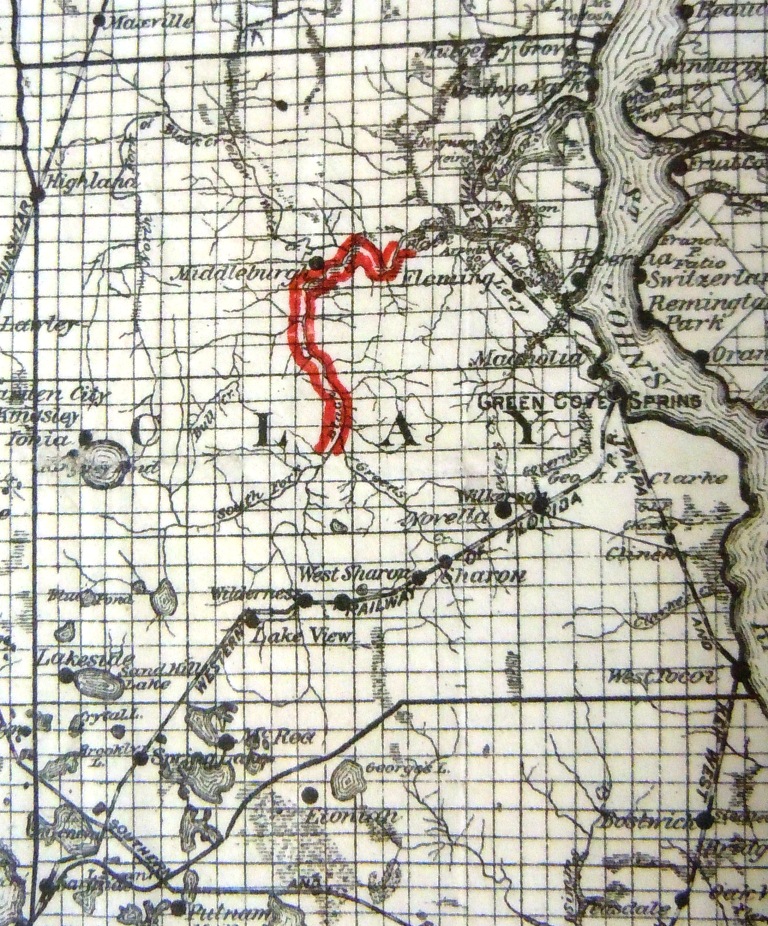
1902 Cram
The Florida Railroad is shown with the Highland stop.
The J, T&KW stops are Orange Park, Peoria, Willford, Fleming, Magnolia Springs, Green Cove Springs, Wallkill, and West Tocoi.
The Green Cove Springs & Melrose is NO LONGER SHOWN. Residual place names that once stopped and appear on the map: Novella, Sharon, Belmore, Springlake, and Newburg. Melrose isn’t shown.
Also shown are Brooklyn, Middleburg, McRae, Kingsley, Ionia, LakeView, Waller, Leno (new), and Oypas (new).
1909 Sanborn Insurance
Green Cove Springs Insurance Maps
Buildings listed individually include ACL RR Depot, Baptist, Church, Clarendon Cottages A & B, Clay County Brickworks, C. B. Eddy Lumberyard, Episcopal Church, Fire Department, Florida Military Academy, Green Cove Springs Independent Line Steamers, Hotel Oakland, Marmaduke Turpentine Mill, Magnolia Springs Hotel and Cottages, Methodist Episcopal Church, Mt. Zion A. M. E. Church, M. Neff Sawing and Planing Mill, Post Office, Presbyterian Church, Public School No. 1, Colored School, Quisisana Hotel (and Spring and Casino), Roman Catholic Church, Riverside Hotel, St. Clair Hotel, Tyler House, Village Library.
1910 Charles A. Brown Rel Estate Promotional Plat
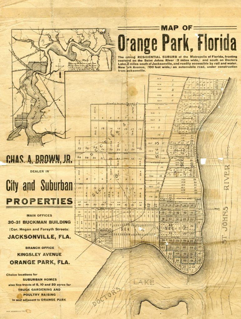
Charles A. Brown was a real estate agent in Jacksonville. He owned what is now the Holly Point area of Orange Park. He arranged for the land sale to Yerkes for the Monkey Farm. This map shows the JT&KW railroad but not State Highway 3, probably between 1884 and 1917.
It has one of the only references to Tululu Springs, which Brown may have also owned.
1916 National Map Co.
The Florida Railroad is shown with the Highland stop.
The J, T&KW stops are Orange Park, Peoria, Willford, Russell (instead of Fleming), Magnolia Springs, Green Cove Springs, Wallkill, and West Tocoi.
The Green Cove Springs & Melrose is NO LONGER SHOWN. Residual place names that once stopped and appear on the map: Belmore, Newburg, Melrose.
Also shown are Brooklyn, Kingsley, Waller, Leno
Middleburg, curiously, isn’t shown, perhaps because there wasn’t room to print.
1917 Florida
Official State Road Map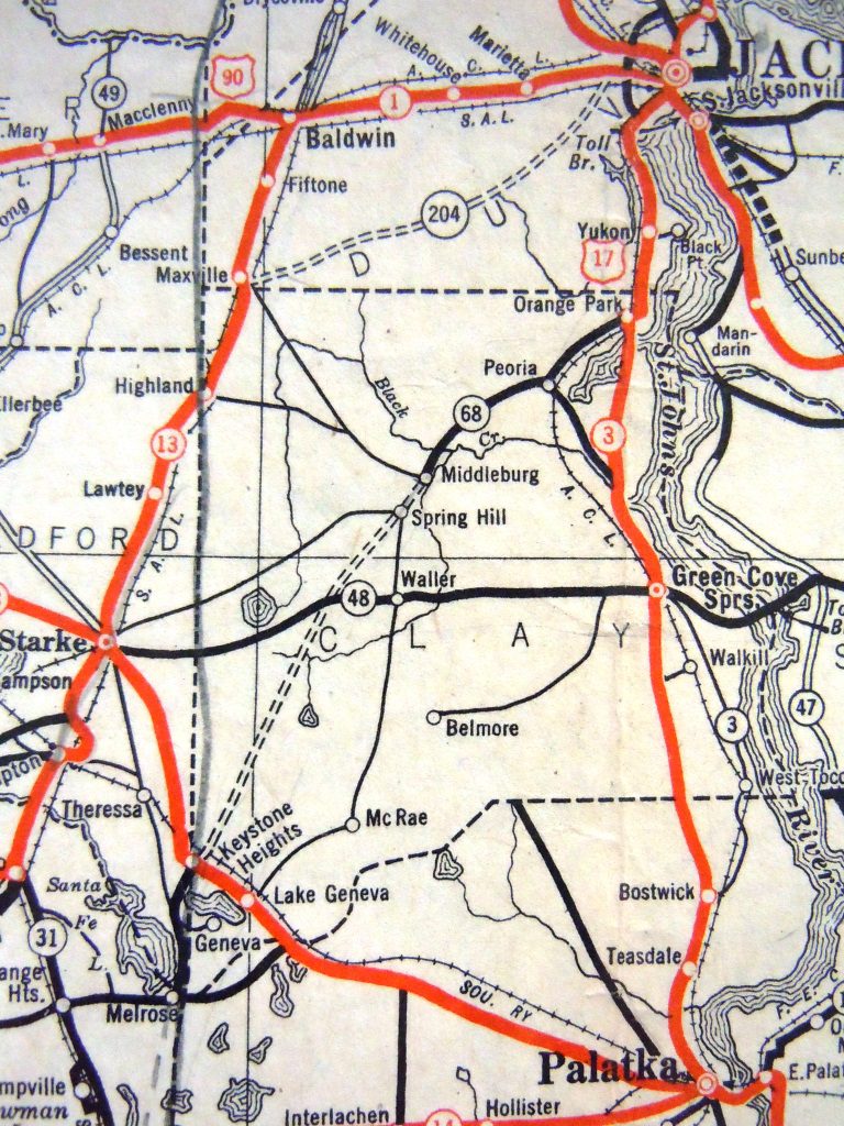
The only (partially) paved road is the state highway along the river, west of Doctors Lake.
A curious railroad extends from Starke to just sw of where Penney Farms would one day be. No stops are shown. Possibly a temporary timberline, but no other reference has been found.
The Florida Railroad is shown with the Highland stop, from which a road runs to Middleburg.
The J, T&KW stops are Orange Park (marked but unnamed), Peoria, Willford (marked but unnamed), Russell, Magnolia Springs, Green Cove Springs, Wallkill, and West Tocoi.
The Green Cove Springs & Melrose is NO LONGER SHOWN. Residual place names that were once stops and appear on the map: only Belmore and Melrose. However, for the first time, a dirt road appears from Green Cove Springs, straight west, eventually to Starke.
Also shown are Brooklyn, Leno, Prox, Lake Geneva, Waller, Oypas, Rideout, Hibernia,
Several dirt roads extend from Middleburg.
1919 Florida Publishing Guide
Auto Road Map of Florida
 A “pure” road map, showing very few other features. Shows the road from Jacksonville to Palatka on the west side of Doctors Lake. Also shows the road from Palatka to Starke and the one from Starke to Baldwin.
Only two other roads are shown—one to Jacksonville from Peoria and one to Jacksonville from Highland.
Places named: Green Cove Springs, Doctors Inlet, Theressa, Brooklyn.
1920 U. S. Railroad Administration
The Florida Railroad is shown with the Highland stop.
The J, T&KW stops are Orange Park, Mandarin (incorrectly duplicated from the east side of the river), Peoria, Doctors Inlet (instead of Willford), Russell (instead of Fleming), Magnolia Springs, Green Cove Springs, Wallkill, West Tocoi.
The Green Cove Springs & Melrose is NO LONGER SHOWN. Residual place names have dwindled to Belmore, Melrose.
Also shown are Brooklyn, Lake Geneva, McRae, Waller, Leno, Sunnyside (new), and Rideout (new).
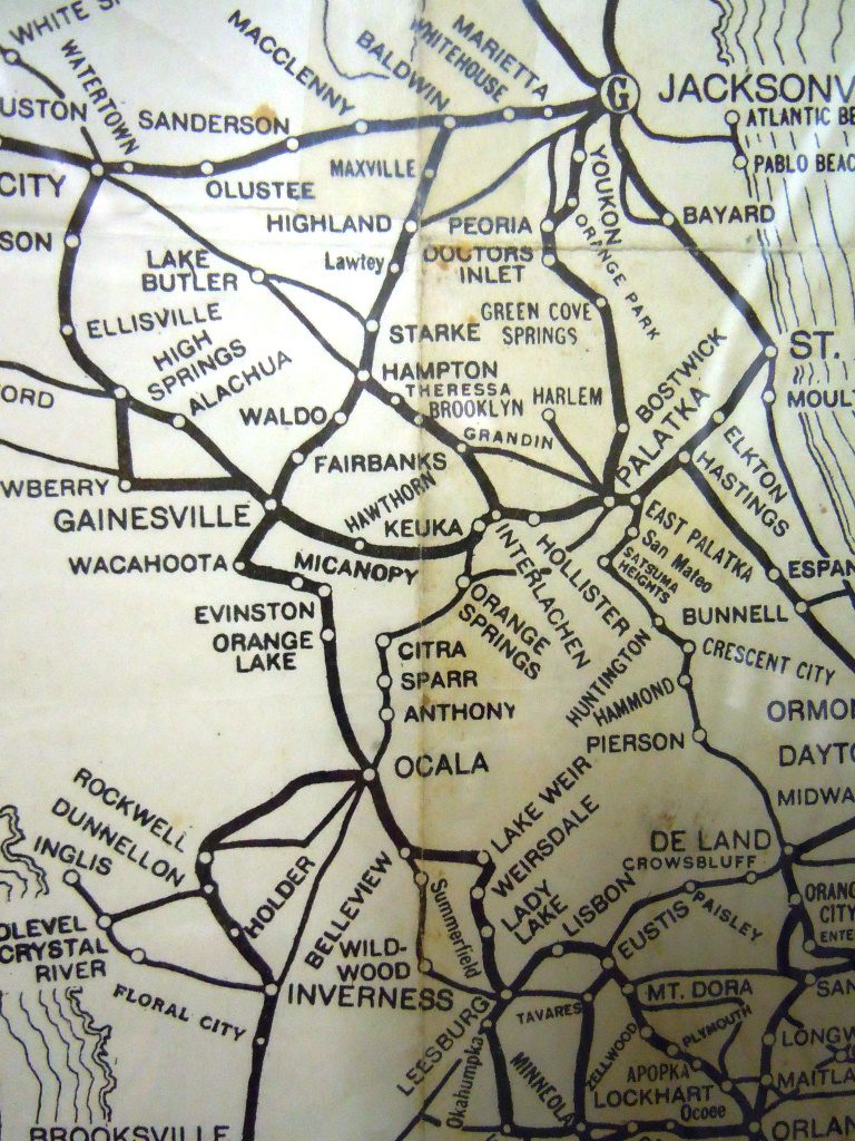
1922 Rand-McNally
Auto Trails Map
 The first widely-used road map of Clay County.
Highway 9 (running along the river, but west of Doctors Lake): Orange Park, Peoria, Magnolia Springs, Green Cove Springs
- Rd from Middleburg to Jacksonville: none
- Rd from Middleburg to Starke: Kingsley
- Rd from Jacksonville to Starke: Highland
A short, direct road also ran from Green Cove Springs to Belmore
1923 Florida
Florida Road Condition Map
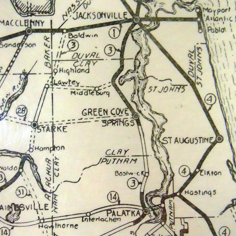
Not much detail is shown.
Highway 3 is paved from Jacksonville to just south of Green Cove Springs and unpaved as it goes south—no other paved roads in the county.
Roads depicted are:
- Green Cove Springs straight west to Starke
- A road from Highway 3 west to Middleburg and then to Lawtey.
1927 Rand-McNally
Junior Auto Road Map of Florida
Except for the paved road running along the river (and west of Doctors Lake), and Highway 13 running along Clay’s western border, only one paved road is shown: Highway 48 between Penney Farms and Green Cove Springs.
The old military road from Middleburg to Jacksonville is shown as unpaved. An unpaved road from Starke to Middleburg and Penney Farms is also unpaved.
1929 Federal Highway Aid program
Federal Highway Aid Program
 This map, originally drawn in 1921 and corrected in 1929, shows only highways paved with Federal Aid. The only one to that date is Highway 13 along Clay’s western border. No other roads are shown.
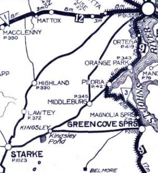
The JT&KW stops are Orange Park, Peoria, Russell, Green Cove Springs, Walkill, and West Tocoi.
Other places shown are Middleburg, Rideout, Highland, Waller, Montezuma, Belmore, McRae, Brooklyn, Lake Geneva, and Melrose.
1929 Standard Oil of Kentucky
Highway 17 is in place, labeled three from Jacksonville to Green Cove Springs. South of there, Highway 3 splits east and goes to West Tocoi.
The JT&KW stops are Orange Park, Green Cove Springs, Walkill, and West Tocoi.
- Highway 48 is now the name of the road running west out of Green Cove Springs to Starke, apparently paved almost to Waller.
- Highway 13 is now the name of the road running along the Florida Railroad.
- Highway 68 (not labeled) runs from Orange Park to Middleburg.
Other places are shown: Spring Hill, Belmore, McRae, Geneva, Melrose, Doctors Inlet,
Black Creek is incorrectly labeled Buck Creek.
1933 Florida
Official State Road Map

Paved roads include:
- Highway 17 (Fl No. 3) appears, and it crosses the mouth of Doctors Lake.
- State No. 13 in the NW along the Florida Railroad
- State Highway from Palatka to Starke, with Lake Geneva and Keystone Heights
Several unpaved roads exist, the most important being from Orange Park to Middleburg.
Places shown include Orange Park, Peoria, Middleburg, Spring Hill, Waller, Belmore, McRae, Geneva, Walkill, West Tocoi, and Green Cove Springs.
1957 Florida
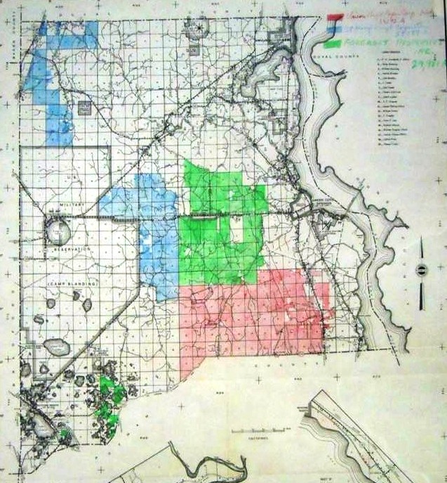 Large Land Ownership
Shows three owners plus Camp Blanding owns one-third of the County. For a key and explanation, read about the timber.