
We’ve accumulated plenty of settlements and towns for a small county over the years. As you’re reading various historical sources, you may find it helpful to refer to this page for some context about various places.
See also Land Grants, most of which did not receive names. Acknowledgment is given to David Rumsey’s map collection and the many public map archives linked below.
So far, the place names have been cataloged until about 1920. Research continues on the following:
- Plat maps
- Map CCA101810: Clarkville, Clay Hill, Durham, Ellaville, Ellsville, Fellowship Park, Maxville, Montezuma, Neilhurst, New Lawtey, Register Bridge, Sungarden, Virginia Village, Yellow Water
- Map CCA101810 Schools: Brownsville, Bulman, Dowling Bridge, Grove Park, Hickmon Ford, Pine Grove, Pine Level, Providence, River’s Mill, Rose Hill, Station Pond, Swimming Pen, Taylor Landing
- Place Name Spreadsheet: Peer Station, Leghee, Doctors Lake, Moosehaven, Fout’s Mill, Pass Station, Camp Blanding, Gold Head, Hatcherville, Hewitt, Waterloo
- Fl State Archives Nautical Chart
- Cemetery Subject Files
- School board minutes
- Ferry landings
Towns and Settlements A-B
Allen Lake
Named for Wyatt C. Allen (22-8-23)
Ates Creek
A tributary of the South Fork of Black Creek.
Athens
Eighth stop of the Green Cove Springs & Melrose RR Stations. “Parade of Memories” indicates it was also called Belmore, although this may be in error since several maps show them as distinct. It boasted a post office from 1891 through 1894. It last appears on a map in 1897.
Banana
Sometimes used interchangeably with Melrose, but more strictly speaking, a location a little south of Melrose on Etoniah Creek with a Banana Mill (about 1867 – 1910) and a post office (1875 – 1894), slightly outside Clay County.
B & W Junction
Eleventh of the Green Cove Springs & Melrose RR Stations (est. 1882 and closed before 1900). Only once on a map in 1891.
Bayard Tract (later Walkill)
Named for Bayard Clinch, son of Duncan Clinch. Laid out by Duncan Clinch, it didn’t last long because of the Seminole Wars and only appeared on a map in 1835 (courtesy of Roy Winkelman). Later resurrected and mentioned in “Where to Go in Florida,” 1880.
Belmore (or Belmore City; previously called Athens)
 The sixth stop of the Green Cove Springs & Melrose RR Stations. Shown on plat book 1, pg 20. Promoted itself in 1884. Boasted a post office from 1885 through 1917. A cemetery (sometimes called the Evergreen Cemetery at Belmore) was consecrated in 1892. It begins appearing on maps in 1886 (source lost), on a map in 1888 as Delmore (spelling error), and as the end of the line for the uncompleted Green Cove Springs & Melrose Railroad in 1890. It last appears on a map in 1898 (Rand McNally). “Parade of Memories,” pg 6, indicates without source that it was previously called Athens but is shown on several maps as a distinct settlement. (T4-R24)
See Belmore’s original plat (1885)
Parade of Memories (pg. 67) deduces Piney Grove was once called Scrub and may have become Belmore’s nucleus.
Black Creek (area)
Early accounts often refer to Black Creek since no settlement areas had been named yet. The Spanish called it Rio Blanco (White River), and the Seminoles called it Wealuste. The creek system stretches far into the county and was important during colonial and territorial periods. Ft. Heileman used it to float hundreds of shipments of supplies to its storage facilities. Middleburg (previously Garey’s Ferry, Ft. Heileman, and Whitesville) is at the fork of the north and south prongs. A railroad stop was at “Black Creek” from 1888 through 1891.
Black Creek Arsenal
Previously called Garey’s Ferry Ordinance Depot, it lay across the creek from Garey’s Ferry, just opposite the boat ramp. It was positioned away from the fort to avoid explosions. In operation 1837-1840.
Black Creek, Lake of
Appears on the 1865 Civil War Map, Sheet XI. (No other references known. Now called Varnes Lake.)
Bone Esperance
Andrew Pleym’s plantation, where the Lower Crisp had been at Creighton’s Island (North Fleming Island).
Blue Pond
A lake with a small settlement near it. First appeared on a sectional map in 1888 Plant System map and the last in 1897 Rand McNally map. A cemetery was established there before 1869, with the last burial in 1891. In Camp Blanding.
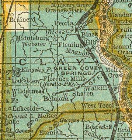
Brainerd (Brainerd; apparently also called Hugh(s))
A stop on the Florida Transit and Peninsular RR (est.1861), called Atlantic, Gulf, and West India RR (from 1872). First appeared on a map in 1888 Plant System map and last appeared in 1894 Matthews-Northrup map.
Brooklyn (see Keystone Heights, which was renamed in 1921)
Brooklyn Lake
Perhaps named by New York soldiers at Fort No. 11
Buck Creek
An incorrect label for Black Creek on the 1933 Official Road Map of Florida
Bull Creek
A tributary of the South Fork of Black Creek.
Burlington Sawmill Grant
A 100-acre tract of the McIntosh estate (Laurel Grove) was sold in 1853 to H. R. Sadler, Sr.
Towns and Settlements C-D
Cain Field (see Elm Springs)
Camp Augusta
Near Walkill. In operation during 1836. See Plat Book 1, page 33, the Clerk of the Court website.
Camp Blanding (which occupies historical Waller and the surrounding area)
Camp Brown (see Fort Brown)
Chautauqua City
Keystone Heights. See their water tower photo in the centerfold of Parade of Memories.
Clarendon
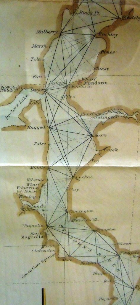
One of a series of visual navigation aids on the west side of St. John’s in Clay County, including Fire (at Duval County line), Doctor (Orange Park), Lake (where Doctors Lake bridge touches Fleming Island), Ragged (Raggedy Point), False, Middle, Hibernia, Wharf, White House, Fleming, Wilkies (just south of Black Creek), Magnolia (Point), (Magnolia) Hotel, David (Green Cove Springs), Clarendon (Hotel), White, Seppho, Draper, Red (Putnam County line) [FL State Archives: US Coast Survey, Progress Sketch Sec. VI, 1877]
Clarks Creek (Clarkes Creek)
A short creek that flows directly into the St. Johns, south of Green Cove Springs. A 1929 map shows the creek system rather well.
Claudia
Mentioned in only reference — the 1899 list of post offices.
Chesuuiskia (Chesuwiskia, Chesawiskia, Cheswiski, Chesuwiski)
Boasted a post office in 1858 and 1859. It lost its post office in 1860 when no one bid for postal route 6519. (see Congressional series of United States public documents U.S. Government Printing Office, 1860 pg.279) “Florida From When We Came” pg 21 indicates Chesuwiski was previously called Thomasville. First appears on a map in 1874 (source lost) and finally in 1882.
Clinch Station
It appears only on the Cram railroad map of 1889 (circa) and in plat book 1, pg 31, in 1898. It was the first of the Green Cove Springs & Melrose RR Stations (est. 1882 and closed before 1900). It is often a station on the JT&KW line where Walkill was.
Clyde (see West Tocoi)
Constancia (Constantia) (see Magnolia Springs)
The name of the Travers Grant is just north of Governors Creek. It is a small part of the British grant to Patrick Tonyn. Later, the Spanish granted it to Thomas Travers. William Travers inherited it and named it after his daughter. His wife Rebecca (Smith) inherited it after his death. She later married Joseph Finnegan, who became the CSA general in command of Florida.
Crisp (or Crispe, Upper Crisp & Lower Crisp)
The Upper Crisp and Lower Crisp (see a detailed treatment) were land grants of James Crisp, who entered into an agreement with the Earl of Egmont during the British Period to develop them. The Upper Crisp comprised what later became Pengree and Kingsley’s Laurel Grove (Orange Park) and stretched far to the northwest. The Lower Crisp was just south of the mouth of Doctors Lake and comprised Creighton Island and more.
David
One of a series of visual navigation aids on the west side of St. John’s in Clay County, including Fire (at Duval County line), Doctor (Orange Park), Lake (where Doctors Lake bridge touches Fleming Island), Ragged (Raggedy Point), False, Middle, Hibernia, Wharf, White House, Fleming, Wilkies (just south of Black Creek), Magnolia (Point), (Magnolia) Hotel, David (Green Cove Springs), Clarendon (Hotel), White, Seppho, Draper, Red (Putnam County line) [FL State Archives: US Coast Survey, Progress Sketch Sec. VI, 1877]
Devil’s Wash Basin
Now called Deer Lake. In Gold Head State Park
Doctor
One of a series of visual navigation aids on the west side of St. John’s in Clay County, including Fire (at Duval County line), Doctor (Orange Park), Lake (where Doctors Lake bridge touches Fleming Island), Ragged (Raggedy Point), False, Middle, Hibernia, Wharf, White House, Fleming, Wilkies (just south of Black Creek), Magnolia (Point), (Magnolia) Hotel, David (Green Cove Springs), Clarendon (Hotel), White, Seppho, Draper, Red (Putnam County line) [FL State Archives: US Coast Survey, Progress Sketch Sec. VI, 1877]
Doctors Inlet (most likely prev. called Willford)
 Doctors Inlet boasted a post office from 1913. Plat book 2, pg 17, shows its railroad depot. It first appears on a map in 1920.
Doctors Lake (rarely called Lake Levett)
Briefly called Lake Levett (after Francis Levett’s land grant) during the British period, it has been known as Doctors Lake since the second Spanish period.
Maps:
The 1890s show Bardin estate, now the Doctors Lake Estates area, along with four large lots running the extent of the west side of the lake.
Draper
One of a series of visual navigation aids on the west side of St. John’s in Clay County, including Fire (at Duval County line), Doctor (Orange Park), Lake (where Doctors Lake bridge touches Fleming Island), Ragged (Raggedy Point), False, Middle, Hibernia, Wharf, White House, Fleming, Wilkies (just south of Black Creek), Magnolia (Point), (Magnolia) Hotel, David (Green Cove Springs), Clarendon (Hotel), White, Seppho, Draper, Red (Putnam County line) [FL State Archives: US Coast Survey, Progress Sketch Sec. VI, 1877]
Durham
A very short-lived community, boasting a post office from 1897-1900. Not map references found.
Towns and Settlements E-F
Elm Springs (Fuente de Alamo)
Englewood
Only listed on the 1886 list of post offices.
Etoniah (Etoniah Scrub) (once misspelled Ekoniah)
A region of Indian encampments on the Clay – Putnam border. Some early accounts describe the interior of Clay as Etoniah, including Louise Seymour Townsend’s travel account, “Ekoniah Scrub.”
Federal Hill
Boasted a post office from 1887 through 1894. A northern man tried to develop it, charging Southerners more for lots than Northerners. Not surprisingly, it didn’t thrive. The Archives retain a subject file containing a beautiful town map showing Lincoln Park at its center, along with a pamphlet and other items. Only its cemetery survives.
False
One of a series of visual navigation aids on the west side of St. John’s in Clay County, including Fire (at Duval County line), Doctor (Orange Park), Lake (where Doctors Lake bridge touches Fleming Island), Ragged (Raggedy Point), False, Middle, Hibernia, Wharf, White House, Fleming, Wilkies (just south of Black Creek), Magnolia (Point), (Magnolia) Hotel, David (Green Cove Springs), Clarendon (Hotel), White, Seppho, Draper, Red (Putnam County line) [FL State Archives: US Coast Survey, Progress Sketch Sec. VI, 1877]
Fire
One of a series of visual navigation aids on the west side of St. John’s in Clay County, including Fire (at Duval County line), Doctor (Orange Park), Lake (where Doctors Lake bridge touches Fleming Island), Ragged (Raggedy Point), False, Middle, Hibernia, Wharf, White House, Fleming, Wilkies (just south of Black Creek), Magnolia (Point), (Magnolia) Hotel, David (Green Cove Springs), Clarendon (Hotel), White, Seppho, Draper, Red (Putnam County line) [FL State Archives: US Coast Survey, Progress Sketch Sec. VI, 1877]
Fleming
One of a series of visual navigation aids on the west side of St. John’s in Clay County, including Fire (at Duval County line), Doctor (Orange Park), Lake (where Doctors Lake bridge touches Fleming Island), Ragged (Raggedy Point), False, Middle, Hibernia, Wharf, White House, Fleming, Wilkies (just south of Black Creek), Magnolia (Point), (Magnolia) Hotel, David (Green Cove Springs), Clarendon (Hotel), White, Seppho, Draper, Red (Putnam County line) [FL State Archives: US Coast Survey, Progress Sketch Sec. VI, 1877]
Fouts Mill
Martin Fouts. A settlement named in the 1910 Census.
Fuente de Laurel (see Springfield)
Fuente de Alamo (see Elm Springs)
Fleming Island
Previously called Hibernia (i.e. Ireland) by Georgia Fleming, who received a Spanish land grant. During the British Period called Hawkes Island. Home of the Fleming Family. Hibernia first appeared on a map in 1823, and Fleming first appeared in 1837. Boasted a post office from 1849 to 1931. Many resources are related to this area, including “Hibernia: The Unreturning Tide” by Margaret Seton Fleming, available in the Archives. A cemetery was consecrated at St. Margaret’s in 1821 and remains active. Fleming sported a railroad stop from 1888 for about twenty years.
Florence (See Newburg)
Appearing on a map only once in 1891, it is possible that the map is in error.
Florence Mills (See Novella)
Flowers Prairie
Named after Lewis Flowers, about 1880 (36-8-23)
Fort Bayard (See Camp Augusta)
Fort Brown
Mentioned in Brennan’s land grant, otherwise unknown.
Fort Fuegers (or Fuegers Fort)
Only shown on one map in 1829. Shown on the north side of the North Fork where the Ft. Heileman armory later stood.
Fort Heileman (at the boat ramp in Middleburg; See Middleburg)
Ft. Heileman was a Second Seminole War army fort with an associated supply depot. An archaeological dig was completed to examine exposed bricks.
Fort Magnolia
Hastily erected during the Civil War. See Magnolia Springs.
Fort No. 11
At Lake No. 11
Fort Sanderson
A temporary fort of the Seminole War period 1840-1841. At least one private, Lyman Franklin Rounds, was known to enlist there on Sept 27, 1840, into the 7th Infantry Co. Exact location unknown.
Fort Van Cortland(t)
Near Kinsley Lake in 1839 (Seminole Wars)
Fouts Mill
A mill in southwest Clay County. An election precinct name in the same area according to the 1930 census map
Towns and Settlements G-H
Geneva (see Lake Geneva)
Glorat (see Magnolia Springs)
Glorat is mentioned in the Travers grant in “Spanish Land Grants in Florida,” pg 155 and 157.
Garey’s Ferry (named after Samuel Garey and site of Ft. Heileman; See Middleburg; sometimes misspelled Gary’s Ferry or Carrie’s Ferry)
Good Fortune
Ambrose Hull’s plantation on Doctors Lake.
Governors Creek
Named for British Governor Patrick Tonyn, whose plantation was situated at its mouth. Tonyn received the land grant before he was made governor.
Green Cove Springs
Originally the George Clarke land grant, Green Cove Springs was established in 1854 as White Sulphur Springs because of its large artesian flow. It was renamed in 1866 to Green Cove Springs, took the county seat from Whitesville (Middleburg) in 1871, and incorporated in 1874. It was fortunate to enjoy two heydays, the first being the Hotel Era from after the Civil War to the Great Depression, and a second when, after WW II, the Mothball Fleet of retired naval vessels was towed there for decommissioning. Green Cove Springs appears on an 1874 map. It boasted a post office beginning in 1848. Green Cove Springs is home to the Clay County Archives, the Military Museum, and the History and Railroad Museum. It is home to the Village Improvement Association, the oldest Woman’s Club in Florida, which opened the County’s first library there.
Green Pond
Named after Burrell Green, about 1860 (25-8-23)
Harmony Hall (or Harmony House)
Artemis Ferguson’s plantation at Swimming Pen Creek.
Hawkes Island
Called Hawkes Island after the British Lord Hawke, it later became Fleming Island.
Hibernia (see Fleming Island)
Also:
One of a series of visual navigation aids on the west side of St. John’s in Clay County, including Fire (at Duval County line), Doctor (Orange Park), Lake (where Doctors Lake bridge touches Fleming Island), Ragged (Raggedy Point), False, Middle, Hibernia, Wharf, White House, Fleming, Wilkies (just south of Black Creek), Magnolia (Point), (Magnolia) Hotel, David (Green Cove Springs), Clarendon (Hotel), White, Seppho, Draper, Red (Putnam County line) [FL State Archives: US Coast Survey, Progress Sketch Sec. VI, 1877]
Hall Lake
Named after Lyman Hall, about 1860 (17-8-24)
Hamlyn (Hamlin) Lake
Named after Walter Hamlyn’s grove there (5-9-23)
Herbert
Appearing only once, without any other historical reference, on the 1837 Williams map.
Highland ( Highland Station, Trail Ridge)
Trail Ridge was a settlement along the important Alachua Trail (Native American) (see “The Story of The Florida Railroads” by Pettengill). A railway from Fernandina later ran along the ridge, which was the Florida seashore in prehistoric times. Highland was the highest point on the line at 210 feet. Its name first appears in a Message from the President in 1838 and on a map in 1863. Its name was changed to Highland in 1874 and is shown on a map in 1882. Two other Clay County settlements were on the Alachua Trail — Mrs. Monroe’s (1836) and Ionia’s (1888).
Webb’s directory (1885) indicates Highland had one store, a lumber mill, and about 200 people.
Hillsford/Willford
Mentioned only once in the 1898 Annual Report of the Railroad Commission of Florida, where it was misspelled.
Hotel
One of a series of visual navigation aids on the west side of St. John’s in Clay County, including Fire (at Duval County line), Doctor (Orange Park), Lake (where Doctors Lake bridge touches Fleming Island), Ragged (Raggedy Point), False, Middle, Hibernia, Wharf, White House, Fleming, Wilkies (just south of Black Creek), Magnolia (Point), (Magnolia) Hotel, David (Green Cove Springs), Clarendon (Hotel), White, Seppho, Draper, Red (Putnam County line) [FL State Archives: US Coast Survey, Progress Sketch Sec. VI, 1877]
Hunters Mill ( renamed later to Smaile’s Switch)
Fifteenth stop of the Green Cove Springs & Melrose RR Stations. First appears only once on a map in 1893.
Towns and Settlements I-L
Indian Boundary Line
To keep the peace, the British governor Grant convened a congress with the Indians at Picolata and established a line across which Indians and settlers were not allowed to cross. This worked well during the British period but was ineffective during the later Spanish period. The area was not well mapped in the 1760s, but it is clearly shown on the 1823 Vignoles map.
Ionia
Mrs. Monroe’s and Trail Ridge (Highland) are one of three settlements along the Alachua Trail Trail. It first appears on a map in 1888, but it boasted a post office from 1886 to 1903.
Ivatanoa (Joltanoga, Jotanoga, Ilatamaa, Jurlanoca)
Yamasee and/or Seminole Indian settlements. One may be in the forks of Black Creek, and there are reports of later Seminole Indian huts in the Middleburg vicinity. They appear on several maps (1677 Ivatanoa in Timucuan chiefdoms of Spanish Florida. Vol. 2 by John Worth, and again in 1694 in Archaeology of Mission Santa Catalina de Guale by Amy Turner Bushnell.
Maps showing the settlement:
- 1742 Ilatamaa on Covens
- 1776 Joltanoga on Romans
- 1816 on Melish
- Joltanoga (Jotanoga) is 25 miles from Pupo on the Apalachee trail, as shown on an 1816 map.
Kellums (or Kellums Junction)
Ninth of the Green Cove Springs & Melrose RR Stations (est. 1882 and closed before 1900). First appearing on a map in 1897 and last in 1900. It was one of the few stops without a post office. The Kellum family is known to have been in the Clay County area as early as 1846.
Keystone Heights (renamed from Brooklyn in 1921)
Keystone Heights was called Brooklyn until 1921. Brooklyn boasted a post office from 1877 through 1910. It was a stop on the Georgia Southern & Florida RR (Est 1890 and closed in1950s). First appeared on a map in 1882. In 1921, J. J. Lawrence moved to the area from Pittsburg and began promoting it as Keystone Heights. The Keystone Inn opened in 1924, and the town was incorporated in 1925. It first appeared on a map much later in 1932, hinting at the poor roads in that area. It is detailed in “Parade of Memories.”
Keystone Heights Airport was constructed in 1942 as Crystal Lake Airfield and was commissioned in December 1942 as Keystone Army Airfield (AAF) by the US Airforce. It was used as a tactical combat simulation school. After WWII, the facility was turned over to the City of Keystone Heights (1947).
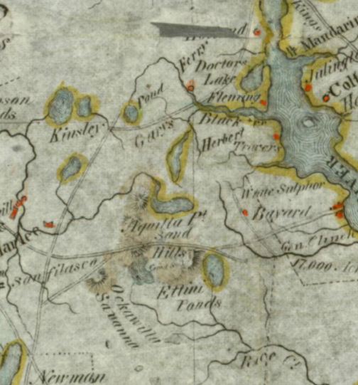
Kingsley (settlement)
First appeared on a map in 1874 (source lost) and again in 1882. It boasted a post office from 1878 through 1906. It is mentioned in “The Key Line” (1884): “[Capt. S. J. Temple] has established a tram road to Kingsley, six miles distant [from Temple Station, Bradford County], one of this region’s most attractive and prosperous places. It is ten miles from Middleburg, the head of navigation for steamboats on Black Creek, a tributary of the St. John’s River, and is situated on the shore of Kingsley Lake, a beautiful sheet of clear water, almost perfectly circular and about two miles in diameter, whose surface is some ninety feet above tide-water, giving on its outlet to Black creek a magnificent water-power. High, wooded banks surround the lake, and a colony of enterprising Northern people settles in the vicinity. Hunting, fishing, boating, etc., are among the amusements many winter visitors enjoy, who find pleasant quarters in private families.”
Founded by Simeon Strickland in 1859, nine miles south of Highland. Webb’s directory (1885) indicates it had two churches.
Kingsley’s Pond / Kingsley Lake
Named for Zephaniah Kingsley of Laurel Grove. The surveyor who first surveyed the lake area was friends with Kingsley and is believed to have named the lake after him. A cemetery was established there as early as 1859 when J. V. Prevatt was buried there, now owned by the Kingsley Lake Baptist Church. Ann Monroe received a land grant there in 1839 (see Parade of Memories), followed by John Harden, Philip Cox, Joseph Truluck, Cassel Sullivan, Randolph Chalker, and others.
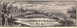
A stop on the Georgia Southern & Florida RR (est 1890 and closed in the 1950s). The first appears on a map in 1888 and again in 1894. It boasted a post office in 1908 and 1909. It is described in “Parade of Memories.” Hiram Alderman’s on Lake Geneva is shown in the travelogue “Ekoniah Scrub” by Louise Seymour Townsend. This etching (c1880) is one of the first landscapes showing detail in Clay County.
It was originally called Lake No 11, but its name was changed to Lake Geneva when the Santa Fe Canal Co. was organized.
Lake Gertrude
Named after Gertrude Meriam (32-8-23)
Lake Levett (see Doctors Lake)
Lake No. 11
Lake Geneva is called Lake No. 11 on Territorial Surveys.
Lake View (or Lakeview, or Lake View on Kingsley Lake)
Tenth of the Green Cove Springs & Melrose RR Stations (est. 1882 and closed before 1900). First appearing on a map in 1886 and again in 1891. It boasted a post office from 1886 through 1900. The Tropical Land Co. had great plans for establishing Lake View in 1885 and published an ad and map in the Jacksonville Board of Trade Report of that year. As it turned out, the line from Belmore ran farther south and bypassed Lake View.
Lakeside (on Sandhill Lake)
It first appears on a map in 1891. It last appears on a map in 1900. It boasted a post office from 1881 through 1902. Webb’s directory (1885) indicated it was settled in 1881 by Mr. M. W. Lee, the postmaster, 1885. It had 150 people and a church. It is situated on rising ground about 25 feet above the level of Sand Hill Lake.
Laurel Grove
Well known as the first Kingsley Plantation (at Orange Park) in the second Spanish period. He purchased it from Rebecca Pengree (William Pengree’s widow). Previously part of the Upper Crisp during the British period. Burned by Ana Kingsley to keep it from rebels. Substantial treatment can be found in “Early History of Clay County,” “Parade of Memories,” and several publications about Kingsley. First appears on a map much later than it was formed, in 1874. The name was retired when Washington Benedict developed Orange Park. Boasted a post office from 1866 to 1874.
Zephaniah Kingsley sold the plantation to John Houston McIntosh in 1817, who sold it to Stephen Bryan in 1853.
Harriett Beecher Stowe was well acquainted with the property in the late 1860s and in Palmetto Leaves, she wrote a few paragraphs about the ex-slaves community there.
Leno
Early maps show Leno west on Clark’s Creek, but later it apparently moved east and became a railroad station. Whether the ACL RR borrowed the name or the settlers actually happened to move is unclear.
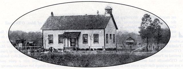
Long Branch (see Penney Farms, to which it was renamed in 1927)
The school at Long Branch is shown.
This town was developed by Florida Farms & Industries, which built a canning plant in 1921.
Lower Crisp (see Crisp)
Towns and Settlements M-N
Magnolia Cemetery
In Orange Park. Not to be confused with Magnolia Springs Cemetery. Moosehaven Cemetery is a section of the Magnolia Cemetery grounds.
Magnolia Springs (The Tonyn Plantation, Santa Thomasa(o), Glorat, Constancia / Constantia, Magnolia Mills)
Part of the Tonyn land grant in the British period, Magnolia Springs later passed to Thomas Travers, his son William Travers, William’s wife Rebecca Travers, then to her husband Joseph Finnegan, who sold it to Summerlin, who sold it to Nathan Benedict, who sold it, Seth Rogers, then to Fay & Cruft, then to Seavey. It has a long history stretching as far back as 1763. It saw activity during the Seminole Wars (called Camp at Magnolia in 1839) and the Civil War. Its glory days were the hotel era when the Magnolia Springs Hotel was in operation, and as it faded, the Florida Military Academy moved in. A Brief History of Magnolia Springs has been prepared, and 400 pages of source documents are available at the Archives. A cemetery was consecrated at Magnolia Springs but is no longer active and is owned by the county. Boasted a ferry for a brief period and a sawmill. A post office was in operation from 1848 to 1926. A J, T&KW (ACL) railroad depot served the hotel. A long pier served steamboats. See Plat Book 1, pg 14.
McIntosh Plantation (Mackintosh)
McIntosh bought Laurel Grove from Kingsley. See Laurel Grove.
McRae
One of the only settlements that was even near Bellamy Road. I boasted a post office from 1883 through 1916. It first appeared on a map in 1888 and finally in 1920.
Melrose (Melrose Crossing, prev. called Shakerag)
A settlement existed at Melrose as early as 1864, when a letter survives calling it Shakerag. Melrose first appears on a map in 1888. Melrose is split into Putnam, Clay, and Bradford counties. Two important histories of Melrose have been written by Zonira Hunter Tolles: “Bonnie Melrose” and “Shadows in the Sand.” The terminus of the Green Cove Springs & Melrose RR (est. 1882 and closed before 1900). Situated at Lake Santa Fe.
Middle
One of a series of visual navigation aids on the west side of St. John’s in Clay County, including Fire (at Duval County line), Doctor (Orange Park), Lake (where Doctors Lake bridge touches Fleming Island), Ragged (Raggedy Point), False, Middle, Hibernia, Wharf, White House, Fleming, Wilkies (just south of Black Creek), Magnolia (Point), (Magnolia) Hotel, David (Green Cove Springs), Clarendon (Hotel), White, Seppho, Draper, Red (Putnam County line) [FL State Archives: US Coast Survey, Progress Sketch Sec. VI, 1877]
Middleburg (Garey’s Ferry, Ft. Heileman)
First called Garey’s Ferry after Samuel Garey, in the Niles Register in 1836. It appeared on the 1837 John Lee Williams map and the 1842 Breese map, and even though its name had changed eventually to Middleburg appeared on the Letts map as late as 1883. It was the site of Ft. Heileman, at the exact fork of Black Creek up to the park near the boat ramp during the Second Seminole War. The name Middleburg first appears on a map in 1864. A cemetery was established at Ft. Heileman and another across the north prong (Branning’s). This area is well-treated in both “Parade of Memories” and “Early History of Clay County.”
An old Indian site called Joltanoga (Jotanoga) is 25 miles from Pupo on the Apalachee trail, as shown on an 1816 map, and located where Middleburg is now.
Mill Cove
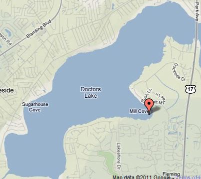
A bay on the south side of Doctors Lake indicates the probable location of an early saw or sugar mill. Also, the location of a small bombing range during WWII.
Mrs. Monroe’s
One of three settlements on the Alachua – St. Mary’s trail, Trailridge (Highland), and Ionia. It sat at the intersection of the Alachua – St. Mary’s trail and the trail to Black Creek. It was a roadhouse (inn) far out in the country and must have been a frightful place. Indians burned it in 1836 (Niles’ Weekly Register, Volume 50 H. Niles, 1836 – ). It appears again on an 1864 Civil War map, so that it may have been rebuilt, or the copyist may not have known it no longer existed. It is mentioned in the Florida State Laws (pg 112 A Digest of the Statute Law of Florida of a General and Public Character: In Force Up to the First Day of January 1872 )C. H. Walton, state printer, 1872 – Florida – 838 pages) to describe the eastern boundary of Columbia County.
Transcribed from Bradford County Telegraph, 100th Anniversary Edition, 1979, section 2, pg 3 “What about this lady who was so well known that her name appears on military maps of the Civil War period, now on display in the museum at Olustee Battlefield State Park? Based on the meager information available, it is believed that Mrs. Monroe had a farm at this well-traveled intersection and likely operated a “rest stop” in the days of horse-drawn vehicles, offering food and rest for weary travelers. The farm was apparently located on the north side of present Highway 230 at the site where the DuPont Company’s new dredge was assembled last year and is now operating. Also in this area was an Indian War Fort, Van Cortland, built to protect early settlers around Kingsley Lake and elsewhere in the sandhill area of Trail Ridge. Bits of broken crockery, bottles, and other household items have been found in recent years at the site of Mrs. Monroe’s, as well as Spanish coins dating back to 1773 and several American coins, including a three-cent piece dated 1833, and others from 1840, 1846 and 1851. These coins were salvaged by Kenny Scarbro, a maintenance engineer with the DuPont Company, from the sump of the dredge that sucks up ilmenite ore from a moving lake. All the coins were badly bent or mangled by passing through the dredge crusher.
Montpellier
Daniel Plummer’s Spanish land grant along St. Johns. Later bought by Ambrose Hull.
Mount Laurel
Usually called Laurel Grove.
Mudge
A stop on the Florida Transit and Peninsular RR (est.1861), called Atlantic, Gulf, and West India RR (from 1872). The only reference is in 1929.
Nepumocino Creek
Creek runs from St. Johns River State College through Doctors Lake Estates. Shown on Pengree’s Elm Springs land grant. Named after Gov. Queseda.
Newburg (shown as Florence in 1891)
Thirteenth of the Green Cove Springs & Melrose RR Stations (est. 1882) closed before 1900). First appeared on a map in 1891, where it is called Florence, and finally in 1916. Maps may copy each other so that their printed appearance outlasted their populated status. It boasted a post office from 1891 through 1894, kept in the home of Bill Chestnut (see Parade of Memories, pg 221).
Novella (Novilla, Florence Mills)
The third stop of the Green Cove Springs & Melrose RR Stations. Webb’s directory (1885) indicates it was established by G. E. Hunt, the postmaster, in 1883. It is located on a bluff overlooking the railway. It has a school. Boasted a post office from 188
Towns and Settlements O-P
Palan (possibly earlier called Chesuuiskia)
One of the few settlements to appear between the Seminole Wars and the Civil War. It boasted a post office from 1858 through 1867. Its first and only appearance on a map is in 1865 (General Topographical Map Sheet XI) as a cluster of houses on a trail from Middleburg southeast to Bellamy Road. It may have succumbed to Civil War hostilities.
The Parlor City
Green Cove Springs.
Oak Ridge (Perhaps later called Oypas)
Boasted a post office in 1889. No other references.
Old Hut
A marking on the 1834 Pousson map (in the vicinity of Whitesville / Middleburg. Not otherwise referred to.
Old Field (Oldfield) Pond
(34-8-23)
Orange Park
Originally part of the Upper Crisp and later part of Pengree and Kingsley’s Laurel Grove, Orange Park occupies the north of Doctors Lake. Mills are shown in its vicinity as early as 1864. It was developed in 1877 by Washington Benedict when his development company platted it and sold lots. Its name first appears on a map in 1882, and it was incorporated in 1891 (General Acts and Resolutions Adopted by the Legislature of Florida)
Webb’s directory (1885) indicated that Orange Park had one hotel, three stores, and NO saloon. W. A. Benedict (the founder) was also the principal of the Clay Collegiate Institute. The dock extended 1,400 feet and cost $7,700. Benedict bought the land for Orange Park for $32,500.
Oypas, Oxpas (Perhaps prev. Oak Ridge)
Boasted a post office from 1889 through 1907. First appeared on a map in 1898 (source lost), again in 1900, and finally in 1909. Not much is known other than W. H. Biggs, the Supt. of Registration, lived there and resigned on June 24, 1904.
Penney Farms (prev. Long Branch)
The beautiful retirement community of Penney Farms. Previously it had been promoted by Robert L. Dowling and the Florida Farms & Industries Co. The Archives has an interesting pamphlet trying to attract pecan growers and farmers. J. C. Penney purchased that property and once again promoted
Peoria
The settlement of Peoria enjoyed a post office from 1886 to 1932. It is located in the vicinity of Peoria Road. James Silcox hauled freight with his teams of oxen from Doctors Lake into the county’s interior. Plat book 2, pg 42, shows the location of the railroad depot. It first appeared on a map in 1886 (source lost) and again in 1888, last appearing in 1932.
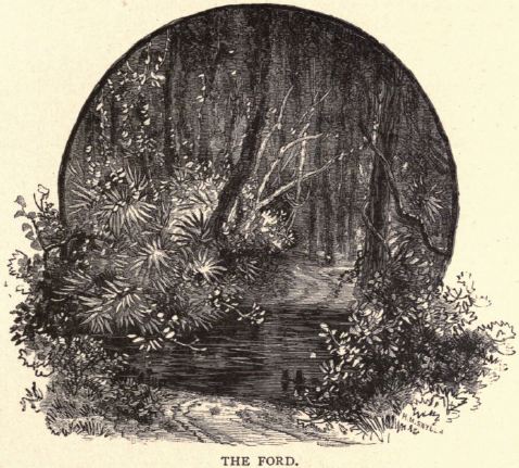
Peter’s Creek
A tributary of Black Creek, starting in the southeast portion of the county, winding around Governors Creek and emptying into Black Creek near where it joins with St. Johns. “The Ford” is shown in the travelogue “Ekoniah Scrub” by Louise Seymour Townsend.
Shown on the circa 1889 Cram map as a station name on the Green Cove Springs & Melrose railroad.
Piney Grove (Pine Grove)
BCC Minutes show a voting precinct was moved from Piney Grove to Fouts Mill.
Owned by Goold T. Butler. See details.
Parade of Memories deduces Piney Grove was once called Scrub and may then have become the nucleus for Belmore.
The Oak Grove Baptist church met in the Pine Grove schoolhouse from 1915 through 1918, when it became defunct.
Pleym’s Island
Now called Creighton Island, after John W. Creighton, who bought Andrew Pleym’s land grant.
Preachers Retreat
Shown on the 1885 Jacksonville Board of Trade Report, on the west side of Kingsley Lake, but not otherwise referred to.
Prox
Associated with Bellamy Road, its exact position is unknown. It has not been found on maps. It boasted a post office from 1911 through 1916.
Towns and Settlements Q-T
Quigley
A very short-lived community, boasting a post office from 1894-1896. No map references were found.
Ragged
One of a series of visual navigation aids on the west side of St. John’s in Clay County, including Fire (at Duval County line), Doctor (Orange Park), Lake (where Doctors Lake bridge touches Fleming Island), Ragged (Raggedy Point), False, Middle, Hibernia, Wharf, White House, Fleming, Wilkies (just south of Black Creek), Magnolia (Point), (Magnolia) Hotel, David (Green Cove Springs), Clarendon (Hotel), White, Seppho, Draper, Red (Putnam County line) [FL State Archives: US Coast Survey, Progress Sketch Sec. VI, 1877]
Red
One of a series of visual navigation aids on the west side of St. John’s in Clay County, including Fire (at Duval County line), Doctor (Orange Park), Lake (where Doctors Lake bridge touches Fleming Island), Ragged (Raggedy Point), False, Middle, Hibernia, Wharf, White House, Fleming, Wilkies (just south of Black Creek), Magnolia (Point), (Magnolia) Hotel, David (Green Cove Springs), Clarendon (Hotel), White, Seppho, Draper, Red (Putnam County line) [FL State Archives: US Coast Survey, Progress Sketch Sec. VI, 1877]
Rideout
Perhaps a phonetic spelling of Ridaught, relating to the Ridaught Indians who did have a presence in Florida. Rideout boasted a post office from 1900 through 1921. A cemetery was consecrated in 1900 as well. It is not found on historical maps.
Ridgewood
Shown on the 1885 Jacksonville Board of Trade Report but not otherwise referred to.
Ridgley’s Mills
At the mouth of Black Creek. 1836. See “Journals of Lieutenant John Pickell,” by Frank L. White, Jr, Florida Historical Quarterly, Vol 38, No 2, October 1959, pg 146. [No Ridgeleys of any spelling variation are mentioned elsewhere in Clay County until George Ridgely (black), who voted in 1876.
Rio Blanco
The Spanish name for Black Creek is odd since the water is so inky black with tannins. However, a theory is that before Budington and others harvested the cypress along the creek banks for shingles and lumber, the creek was ghostly white in the winter when the leaves fall.
Rivers Mill
A settlement named in the 1910 Census.
Russell
Russell boasted a post office from 1900 through 1955, but it doesn’t appear on a map until 1920. For a time, it was a stop on the ACL rail line. The store at Russell was small.
San Francisco de Pupo (Fort, Pupa, Poppa)
Not to be confused with San Francisco — Poppa and San Francisco can be seen separately on the 1810 Arrowsmith map. An archaeological dig was performed by John Goggin in 1951, and he published his results in “Fort Pupo: A Spanish Frontier Outpost” (Florida Historical Quarterly, Vol XXX, No 2, October 1951). He indicates that it was probably first inhabited by Indians in about 1650 and that they may have been forced to abandon it with James Moore’s invasion in 1702. The Spanish built a fort there in 1734, and It first appears on a map in 1736 (Holl). James Oglethorpe invaded Florida in 1739 and overran the fort in 1740. It stopped appearing after 1811 (Carey). The area is slowly eroding into the St. Johns River. It boasts a historical marker. “Early History of Clay County” includes a detailed area treatment.
San Diego de Salamoto (Salamatoto)
Spanish mission. Parade of Memories (pg 4) says it was at West Tocoi; Mark F. Boyd in “Missions Sites in Florida” lists it on the EAST bank of the St. John’s near Picolata (Florida Historical Quarterly, Vol 17, No 4, April 1939). The St. Johns Historical Commission believes it was on the east side and installed a marker there. Blakey’s Parade of Memories references in note 6 must be explored to see if they are persuasive.
Sand Hill (Sandhill) Lake
Sand Hill first appears on a map in 1864. Very rarely referred to. (33-7-23)
Santa Fe Lake
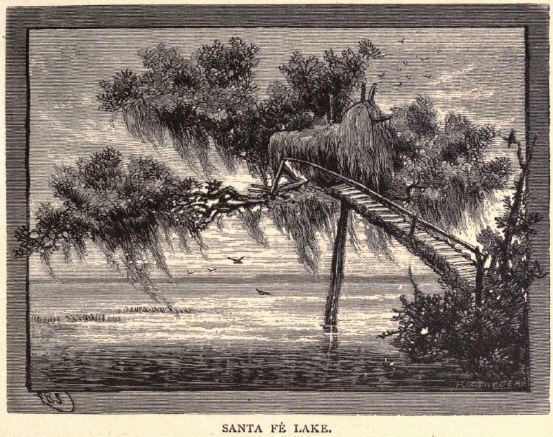
Near Melrose, just west of Clay County. The etching is from the “Ekoniah Scrub” travelogue by Louise Seymour Townsend.
Scrub
Parade of Memories (pg. 67) deduces Piney Grove was once called Scrub and may have become Belmore’s nucleus.
Saranac
Sixteenth of the Green Cove Springs & Melrose RR Stations (est. 1882) closed before 1900). First appearing on a map in 1891 and last in 1900.
Self
A railroad stop between Fleming and Magnolia, it appears on maps only in 1929 and is not otherwise referred to.
Seminole Springs
Usually called Wadesboro Springs, on the west side of Doctors Lake.
Seppho
One of a series of visual navigation aids on the west side of St. John’s in Clay County, including Fire (at Duval County line), Doctor (Orange Park), Lake (where Doctors Lake bridge touches Fleming Island), Ragged (Raggedy Point), False, Middle, Hibernia, Wharf, White House, Fleming, Wilkies (just south of Black Creek), Magnolia (Point), (Magnolia) Hotel, David (Green Cove Springs), Clarendon (Hotel), White, Seppho, Draper, Red (Putnam County line) [FL State Archives: US Coast Survey, Progress Sketch Sec. VI, 1877]
Shakerag
Apparently, in a reference to horse racing, Melrose was apparently called Shakerag early on, including in an 1864 Civil War letter from Brig. Gen Hatch to Col. Noble.
Sharon (sometimes East Sharon and West Sharon)
Fourth and fifth stops of the Green Cove Springs & Melrose RR Stations. Webb’s directory (1885) indicated that Sharon was settled by its postmaster, J. B. Register, and had 250 people. H. E. Bemis established a newspaper in 1884. McGee and Hunt had sawmill (s). Budington, Wilson, and Berry had timberland. J. N. Moore ran turpentine still.
Sharon first appears on a map in 1886. East Sharon and Sharon appear in 1888. Sharon and West Sharon in 1891. East Sharon and Sharon are shown on maps until they disappear after 1898. A cemetery (Sharon, or Salem Baptist Church) was consecrated before 1886.
Smaile’s Switch
Fourteenth of the Green Cove Springs & Melrose RR Stations (est. 1882) closed before 1900). First appeared on a map in 1892, where it is called Florence, and finally in 1900. It boasted a post office from 1891 through 1894. Smaile’s Switch may have originally been called Hunter’s Mill.
Soldiers Pond
After soldiers at Fort No. 11 (19-8-23)
Spring Garden
Spring Garden and Tobacco Bluff were British land grants to John Davis in 1766 along Doctors Lake.
Spring Lake (or Springlake)
Twelfth of the Green Cove Springs & Melrose RR Stations (est. 1882) closed before 1900). First appeared on a map in 1888, again in 1891, and finally in 1894. It boasted a post office from 1890 through 1895.
Springfield (Fuente de Laurel)
Kingsley called it Tulula Springs and established a mill there (see photo in Early History, page 85)
Sugarhouse Cove
On Doctors Lake, just north of Doctors Lake Estates.
Sugar works are shown on the Bien 1865 map, and the cove north of present-day Doctors Lake Estates is still called Sugarhouse Cove.
Sunnyside
Sunnyside boasted a post office from 1908 through 1915, but it doesn’t appear on a map until 1920 and as late as 1929
Swindle Lake
There were several Swindles in the area, about 1880. (11-8-23)
Thomasville (see Wilderness)
Rarely referred to as Thomasville. See a reference in “Florida Place Names” by Morris. The family seat of the Thomas family, Clay County pioneers.
Tiger Head
Site of a Civil War skirmish on a road between Middleburg and Green Cove Springs, October 24, 1864. Described in “Dickinson and His Men,” available in the Archives.
Tobacco Bluff
Spring Garden and Tobacco Bluff were British land grants to John Davis in 1766 along Doctors Lake. No map or survey has yet appeared.
Trail Ridge (see Highland, which it was later called)
Turkey Bluff
A 50-acre plantation belonging to the son of Artemis Ferguson. Across Doctors Lake from Harmony Hall.
Tulula Springs
Part of Kingsley’s holdings, usually called Springfield.
Towns and Settlements U-Z
Virginia Bluff
Ozias Budington & Henry D. Baldwin bought Jonathan R. Wilson’s store and lot on “Virginia Bluff” [Black Creek] Parade of Memories, pg. 35. Not shown on any map. Middleburg.
Wadesboro Springs
Infrequently called Seminole Springs. On the west side of Doctors Lake. Wade bottled water hear from at least the 1880s through the 1920s.
Walkill (Walkill Farms; previously Bayard Tract)
As shown on Plat Book 1, page 33, John G. Borden (of Borden Milk) purchased Clinch’s Bayard Tract and renamed it Walkill. Robert L. Dowling (sometimes incorrectly spelled Dollings) of Ohio purchased Walkill from Borden’s estate and established the Walkill Stock Farms. With his investors, Dowling bought up nearly one-third of the county and established The Florida Farms & Industries Co, hoping to attract farmers. In the end, he failed, and eventually, J. C. Penney bought his holdings in bankruptcy. First appears on a map in 1886, again in 1888, and as last as 1932. It boasted a post office from 1886 through 1913.
Waller (sometimes looks like Walter on fuzzy maps)
Waller boasted a post office from 1893 through 1917. Nicholas O. Waller was its postmaster for a time. He made a curious will (it’s a good read) in 1893 and died in 1898. It first appeared on a map in 1892 and finally in 1920. The E planted twelve thousand acres [Benjamin Talbott Brooks, The Chemistry of the Non-benzenoid Hydrocarbons and Their Simple Derivatives 1922] in 2,000 camphor trees. I Dupont Power Company, used for making gunpowder. Camp Blanding now encompasses what Waller was.
Wealuste
The Seminoles called Black Creek Wealuste and Chief Micanopy spent their early days there. (John Lee Williams, The Territory of Florida: Or Sketches of the Topography, Civil and Natural History, of the Country, the Climate, and the Indian Tribes, from the First Discovery to the Present Time 1837)
Wee Louka (or Wee Iouka)
The area along the St. Johns was only referred to once — in an 1846 map.
West Tocoi
A forlorn place in the best of historical times. It boasted a post office from 1885 through 1925 but not much else. It was primarily a stop on the J, T&KW rail line from which passengers could catch a steam launch, the Louise, [The Bulletin, Volume 10, Issue 0 National Railway Historical Society 1945] from the west side of the river to Tocoi on the other side, and then on to St. Augustine and other places. An 1860 map misspells it Toco, and since no “East” Tocoi is shown, the map may have misplaced Tocoi on the wrong side of the river. It first appears correctly in 1885. In 1900 and 1901, its post office was known as “Clyde” and is shown that way on a 1902 map, probably referencing the Clyde Line steamers. Several references to how poor its depot was dating from 1883 through 1916. A group of block buildings remained until recent years, which had been for the use of black turpentine workers.
Wharf
One of a series of visual navigation aids on the west side of St. John’s in Clay County, including Fire (at Duval County line), Doctor (Orange Park), Lake (where Doctors Lake bridge touches Fleming Island), Ragged (Raggedy Point), False, Middle, Hibernia, Wharf, White House, Fleming, Wilkies (just south of Black Creek), Magnolia (Point), (Magnolia) Hotel, David (Green Cove Springs), Clarendon (Hotel), White, Seppho, Draper, Red (Putnam County line) [FL State Archives: US Coast Survey, Progress Sketch Sec. VI, 1877]
White
One of a series of visual navigation aids on the west side of St. John’s in Clay County, including Fire (at Duval County line), Doctor (Orange Park), Lake (where Doctors Lake bridge touches Fleming Island), Ragged (Raggedy Point), False, Middle, Hibernia, Wharf, White House, Fleming, Wilkies (just south of Black Creek), Magnolia (Point), (Magnolia) Hotel, David (Green Cove Springs), Clarendon (Hotel), White, Seppho, Draper, Red (Putnam County line) [FL State Archives: US Coast Survey, Progress Sketch Sec. VI, 1877]
White House
One of a series of visual navigation aids on the west side of St. John’s in Clay County, including Fire (at Duval County line), Doctor (Orange Park), Lake (where Doctors Lake bridge touches Fleming Island), Ragged (Raggedy Point), False, Middle, Hibernia, Wharf, White House, Fleming, Wilkies (just south of Black Creek), Magnolia (Point), (Magnolia) Hotel, David (Green Cove Springs), Clarendon (Hotel), White, Seppho, Draper, Red (Putnam County line) [FL State Archives: US Coast Survey, Progress Sketch Sec. VI, 1877]
White Springs (or White Sulphur Springs, later called Green Cove Springs)
On the west side of the St. Johns, opposite Picolata, on the Federal Road.
Whitesville (later changed to Webster, and now in Middleburg) (see also, “Old Hut”)
First appeared in 1828 when the County’s first post office was inaugurated there. The post office operated until 1843, when it was moved to Garey’s Ferry (Middleburg). First written about in the Niles Register in 1836. First appeared on the First Territorial Survey in 1833, then again on a map in 1839, then appeared frequently until last in 1883. Its name was changed to Webster in honor of Daniel Webster. Webster first appeared on a map in 1888 and last appeared in 1894. It had assimilated into Middleburg by then. Whitesville/Webster remained a distinct settlement from Garey’s Ferry / Ft. Heileman / Middleburg for most of its existence. (T5-R25-Sec14)
The County Seat from the county’s formation in 1859 through 1871, when it was moved to Green Cove Springs.
Whitesville declined partly because they rejected a proposed railroad, which was diverted to Green Cove Springs. It had four streets: Commerce, Pine, Cedar, and Mulberry, but Parade of Memories (pg 51) doesn’t give a source or a map.
“Bonnie Melrose,” pg 15, claims that Whitesville was named after Doctor White, who had a partnership with an unsavory Frenchman [perhaps Fourgere, of which nothing else is known.]
Wilby
Shown on only one map in 1888 (source lost) and boasted a post office from 1888 through 1891. No other references.
Wilkerson’s (or Wilkinson’s) (station)
The second of the Green Cove Springs & Melrose RR Stations(est. 1882 and closed before 1900). First appears on a map in 1888, again in 1891 as Wilkerson’s, again in 1897 as Wilkinson’s, last appearing in 1898.
Willford (probably later called Doctors Inlet)
Show on Plat book 1, pg 47, Willford was the precursor to Doctors Inlet. It first appears on a map in 1888 (source lost), again in 1900, and on the O’Hern survey in Plat book 1. An 1898 Annual Report of the Railroad Commission of the State of Florida apparently corrupts Willford into Hillsford.
Wilderness (also called Thomasville rarely, then Chesuwiski for a time)
Seventh of the Green Cove Springs & Melrose RR Stations (est. 1882 and closed before 1900). First appeared on a map in 1874, and again in 1882, last in 1898. It boasted a post office from 1874 through 1890.
Webb’s directory (1885) indicated that Wilderness had between twenty and thirty families and boasted one church and a common school. Martin Fouts had an orange grove and was postmaster and a mill, Fouts Mill.
Wilkies
One of a series of visual navigation aids on the west side of St. John’s in Clay County, including Fire (at Duval County line), Doctor (Orange Park), Lake (where Doctors Lake bridge touches Fleming Island), Ragged (Raggedy Point), False, Middle, Hibernia, Wharf, White House, Fleming, Wilkies (just south of Black Creek), Magnolia (Point), (Magnolia) Hotel, David (Green Cove Springs), Clarendon (Hotel), White, Seppho, Draper, Red (Putnam County line) [FL State Archives: US Coast Survey, Progress Sketch Sec. VI, 1877]
Yellow Water Creek
A tributary of the North Fork of Black Creek flowing from Duval County. In the far northwest part of Clay County.